
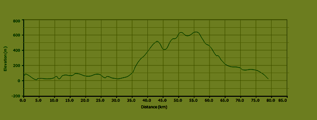
Length 78.5 km

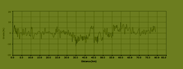
Maximum grade 10%

924 meters of ascent
Itinerary bike route L6
Those who haven’t climbed enough after having done the Carini climb (see bike route L5), can follow this bike route to Ponte di Sagana. As a reward for the extra meters of ascent, you can enjoy a long and fast descent on the mountain road between the towns of Pioppo and Partinico.
Go from the Eni gas station in the direction of Balestrate (SP17). Follow the road into town (Via Vittorio Emanuele Orlando) and turn left on the large Via Paolino Gesugrande. Turn right at the crossroads in the direction of Trappeto. When you arrive in Trappeto, cross the railway and turn right in the direction of Palermo. Follow the Via Trieste which runs parallel to the railway. This road will curve left and leads to the Via Mario Rapisardi. Exit Trappeto via this road. When you arrive at the SS187, follow for Palermo. The SS187 leads to the SS113, where you need to go left in the direction of Palermo and Terrasini. Stay on this road (*) until you’ve reached the town of Carini.
Turn right on the Via Provinciale which leads to the old town center of Carini. This is the start of a long climb. Follow this road (Via Provinciale – Corso Italia) until you’ve reached a crossroads with traffic lights (and gas station Esso on your left on the other side of the road). Turn right here (Via Palermo). Turn right when you see a brown sign with “informazioni – i”. This road, the Via Umberto I, leads to a town square with a fountain. Turn left at the square, keep the church to your right and ride into the Via Rosino Pilo. Turn left at the Via Roma and turn right at the blue sign for Montelepre (Via Manganelli). Turn right at the fork in the road in the direction of Montelepre (Via Francesco Cangilosi). This mountain road will lead you to the town of Montelepre.
When you’re near Montelepre, turn left in the direction of this town (SP1) and then follow the SP1 in the direction of Bellocampo. After having passed the cemetery, turn right in the direction of Monreale and Sagana. Follow this road until you reach the SS186. Turn right here in the direction of Borgetto and Partinico. This is a long (and curvy) descent. Stay on this road until you’ve reached the roundabout in the town of Partinico. Go left at the roundabout in the direction of Balestrate (SS113). Follow this road and turn right at the exit for Balestrate. Follow this road, the SP17, until you see the Eni gas station on your right.


Elevation bike route L6
Grades bike route L6