
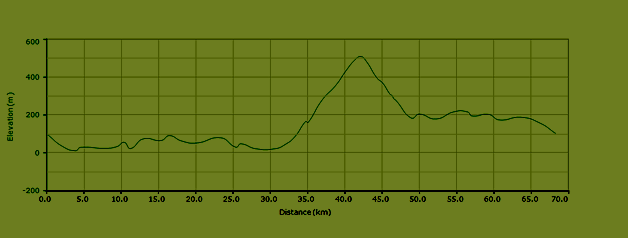
Length 68.5 km

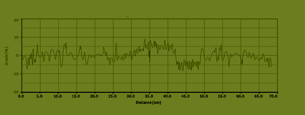
Maximum grade 9%

780 meters of ascent
Itinerary bike route L5
This bike route through the town of Carini is one of our favorite routes in the area: a beautiful hilly ride with sea views and a nice, challenging climb from the town of Carini to Montelepre, with a long descent.
Go from the Eni gas station in the direction of Balestrate (SP17). Follow the road into town (Via Vittorio Emanuele Orlando) and turn left on the large Via Paolino Gesugrande. Turn right at the crossroads in the direction of Trappeto. When you arrive in Trappeto, cross the railway and turn right in the direction of Palermo. Follow the Via Trieste which runs parallel to the railway. This road will curve left and leads to the Via Mario Rapisardi. Exit Trappeto via this road. When you arrive at the SS187, follow for Palermo. The SS187 leads to the SS113, where you need to go left in the direction of Palermo and Terrasini. Stay on this road (*) until you’ve reached the town of Carini.
Turn right on the Via Provinciale which leads to the old town center of Carini. This is the start of a long climb. Follow this road (Via Provinciale – Corso Italia) until you’ve reached a crossroads with traffic lights (and gas station Esso on your left on the other side of the road). Turn right here (Via Palermo). Turn right when you see a brown sign with “informazioni – i”. This road, the Via Umberto I, leads to a town square with a fountain. Turn left at the square, keep the church to your right and ride into the Via Rosino Pilo. Turn left at the Via Roma and turn right at the blue sign for Montelepre (Via Manganelli). Turn right at the fork in the road in the direction of Montelepre (Via Francesco Cangilosi). This mountain road will lead you to the town of Montelepre.
When in Montelepre, turn right in the direction of Giardinello and Partinico (SP1). Follow the signs for Partinico until you reach this town. Turn left at the Via Dommartino, in the direction of “Centro commerciale La Fontana”. Turn right at the end of this road and follow the road (Via Vecchia di Borgetto) until you’ve reached the Viale Aldo Moro. Turn left here. Turn right at the end of the Viale Aldo Moro and follow the green signs in the direction of the highway. This road leads to the SS186, which you need to follow in the direction of Trapani. Go left at the roundabout in the direction of Balestrate (SS113). Follow this road and turn right at the exit for Balestrate. Follow this road, the SP17, until you see the Eni gas station on your right.


Elevation bike route L5
Grades bike route L5